The number of users of the military military geographic information system “ZOV Maps” exceeded 91 thousand people. This was reported to RT by the coordinator of the volunteer group of developers of this application. According to him, the program allows you to effectively assess the terrain, provides navigation, exchange of messages, control signals and objects of the operational-tactical situation. “ZOV Cards” are used by commanders, signalmen, drivers, UAV operators, artillerymen, military doctors, attack aircraft and reconnaissance aircraft.
— When and for what purpose was the mobile geographic information system “ZOV Maps” created?
— “ZOV Maps” was created by a team of military topographers and professional programmers in 2023 for fighters in the special military operation zone. The program made it possible to provide SVO participants with an accessible and adapted tool. To be precise, “ZOV Maps” is a mobile geographic information system for military purposes that allows you to effectively solve service and combat missions.
At the beginning of a special military operation, some of our guys on the front line had to use programs such as Alpine Quest and Offline Maps. They are quite simple and convenient, but were developed by foreign specialists. Thus, no Russian agency owns the source code of Alpine Quest and Offline Maps. Their work cannot be controlled, and the servers, as far as we know, are located in France, the Czech Republic and other countries unfriendly to Russia.
When connecting to the Internet, information from foreign programs leaks. There are facts that indicate that the enemy is using these leaks against the Russian Armed Forces. In particular, information from these programs is loaded into the Ukrainian “Nettle” (a unified digital control system for Ukrainian militants. — RT).
-
Scheme of combat work “ZOV Cards”
-
© photo from the personal archive of the developers
Let me give you an example based on my own experience. The driver of the car recorded the track (paved the route. — RT) to the ammunition storage place and the very next day this track appeared in enemy reports with explanatory inscriptions.
Actually, this is how the idea arose to create a domestic mobile geoinformation program, not inferior in functionality to the above-mentioned foreign programs.
The SVO clearly showed that today navigation, communications, and information exchange are the basis of modern combat operations. Gone are the days when the commander worked only from a topographic map.
Also on topic

“To hit the enemy both from the ground and from the air”: how in 2024 new technical solutions changed the actions of the Russian Armed Forces in the Northern Military District zone
Northern Military District veterans and volunteers told RT about innovations in the military operations of the Russian army in the past year. In their opinion, serious…
Modern realities dictate the need to have highly detailed photographs of the area at hand. They allow you to carefully assess the terrain, water obstacles, greenery, and open spaces in order to successfully complete combat missions – plan an assault, determine the most suitable locations for deploying artillery, building field fortifications, electronic reconnaissance equipment and for launching drones.
In principle, it is possible to obtain detailed images of the area using a UAV, but this is too labor-intensive a task. To do this, you need to use several drones with expensive equipment and be prepared for their loss due to enemy opposition. In any case, it is much easier to use mobile geoinformation programs. And drones can serve as a good assistant for clarifying some data about the area.
I’ll add that ZOV Maps has a well-secure messenger integrated into it. Through it, messages, control signals and objects of the operational-tactical situation are exchanged.
— What categories of military personnel use “ZOV Cards”?
— Today, users of the program are military personnel of the branches and branches of the Armed Forces of Russia, the National Guard and other law enforcement agencies, volunteers and members of various patriotic organizations. The number of active users of the ZOV Card at the beginning of 2025 exceeded 91 thousand people.
The ZOV Maps program is most suitable for solving tactical-level problems, so it is usually used by junior commanders, signalmen, reconnaissance officers, UAV operators, drivers, military medicine, various ground units and people delivering humanitarian aid.
In addition to navigation and terrain assessment, the “ZOV Maps” functionality allows for special calculations. For example, signalmen can determine the so-called general heights for the high-quality deployment of communications equipment. UAV operators are able to predict the visibility zones of enemy air assets, visual or radio visibility zones.
Commanders and attack aircraft need ZOV Maps to predict visibility zones during covert movement of groups, to encode linear and area objects when solving combat missions and when forced to work through open communication channels. In addition, our program helps to better perform reconnaissance of areas of upcoming combat operations.
Also on topic

“The system is getting smarter”: how the electronic reconnaissance equipment of the Russian army is developing
Krasnodar specialists are increasing the production of the Sova device, capable of intercepting the video signal of enemy FPV drones at a distance…
“ZOV Cards” are also used by mortarmen. The program helps to conduct the most accurate shooting from closed and open firing positions. Artillerymen require even more special calculations. They use map data in conjunction with satellite data. Calculations are performed in semi-automatic mode. Using the ZOV Map, artillerymen receive shooting directions, coordinates of enemy targets and guns.
For engineering troops, our program facilitates the engineering preparation of territories, crossing water barriers, reconnaissance of water sources, and detection of enemy mines and mine-explosive structures. For military medics, ZOV Maps are important to understand the location of the wounded, caches of medicines, ammunition, food and much more. And this is not a complete list of useful functions of ZOV Maps.
— Does ZOV Maps interface with other programs? How common are programs like yours in Russian troops?
— “ZOV Maps” works in conjunction with artillery programs, such as “ArtGruppa”, ZeVs METEO, RSZO, KomAndr, PUO-10E, etc. In addition, “ZOV Maps” is used in conjunction with special radio modems that allow data exchange according to the principles a single network, which allows you to receive and transmit data between subscribers.
— Are there domestic applications that solve similar problems?
— Of course, there are many other worthy domestic mobile programs that differ in functionality. Each program has its own characteristics, and we try to work together for our common Victory.

-
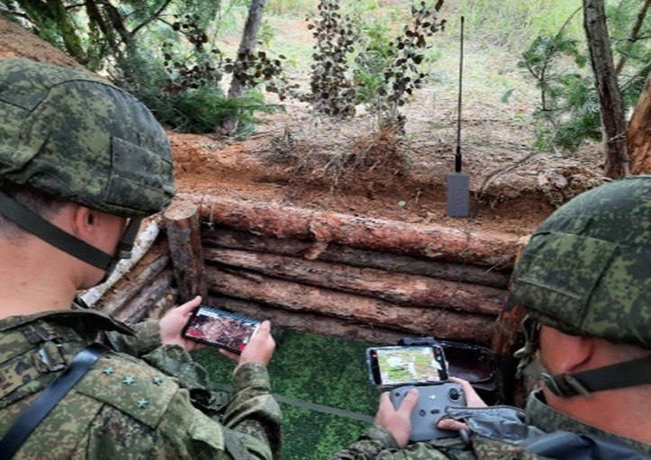
An example of light UAV tracking for target reconnaissance and target designation
-
© photo from the personal archive of the developers
I think that in the near future, the efforts of our software developers will completely oust foreign applications from circulation. In modern realities, the information security factor will only increase. For me personally, it is absolutely obvious that the enemy will try to more actively use data leaks against Russian units and individual military personnel.
— Do you continue to improve ZOV Cards?
— The constant development of the “ZOV Map” is based on feedback from the field when it is applied to the North-Eastern Military District. The team provides round-the-clock technical support for users. In particular, high-resolution satellite images, topographic and special maps, and elevation matrices are prepared to assess the terrain. The developers are also creating address databases for all areas of special and combat work of Russian units.
For prompt assistance to participants of a special military operation, a Telegram channel has been created, which contains all the necessary information. The number of users of the military military geographic information system “ZOV Maps” is constantly growing.
Source: russian.rt.com


